
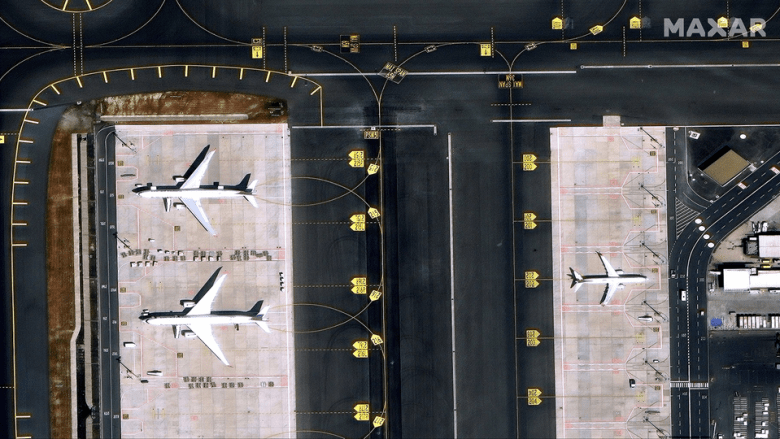
SAN FRANCISCO – Maxar Intelligence’s new global basemap offers 15-centimeter imagery for metropolitan areas.
The 15-centimeter Vivid Advanced HD basemap, introduced July 9, will be particularly important for mapping and navigation applications, said Bryan Smith, Maxar's 2D product manager. Space news.
“In areas where significant change is occurring, our customers need a little more clarity to be able to keep maps up to date,” Smith said. “Whether it’s being able to digitize lane lines or other road features, being able to determine in dense urban environments where buildings begin and end, or what is an alley, sidewalk or road. It takes that kind of clarity that our 15-centimeter HD product provides to meet customer needs.”

Mapping and visualization
Maxar began to offer global satellite images with a resolution of 30 centimeters per pixel in 2023. Prior to that, the Maxar basemap offered a resolution of 50 centimeters worldwide and a resolution of 30 centimeters for select cities.
Customers for the updated imagery include national map makers. Additionally, the maps will serve customers focused on visualization and simulation.
“Flight simulators, for example, fall into that category,” Smith said. Similarly, defense mission planning and analysis often requires background imagery as part of the workflow, he added.

Annual update
For areas of frequent change, Maxar aims for annual updates.
“If you think about where change is happening, it’s happening around population centers,” Smith said. “We still cover population centers because that’s where people live, work and play. But we’ve smartly expanded coverage to those suburbs and specific areas within population centers where change is happening.”
Outside of rapidly changing areas, Maxar aims to update images every two years. Those update rates are “something we'll be able to achieve over time,” Smith said.
Legion's contribution
Maxar’s six-satellite WorldView Legion constellation will support Vivid Advanced basemaps.
“We're excited to have that imagery in our product suite,” Smith said.
The first two WorldView Legion satellites, which acquire 30-centimeter electro-optical images, Released on May 2nd on a SpaceX Falcon 9 rocket from Vandenberg Space Force Base in California.
Legion will provide “an additional 30 centimeters of native capacity that we can then convert into this 15-centimeter HD basemap in areas that are relevant to our customers,” Smith said.